| home | • | bookstore | • | boutique | • | contact us | • | news headlines | • | help! | • | share | • | site map | • | travel center |
 |
 |
 |
| |||||||||||||||||||
| |||||||||||||||||||

|
|
|||
|
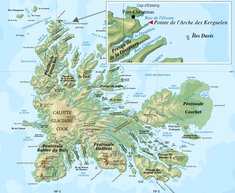
The subantarctic Kerguelen Archipelago (fr. Archipel Kerguelen), located in the southern Indian Ocean approximately 3,300 km (2,051 mi.) southeast of the southern tip of Africa, is among the most isolated places on Earth (see cartographic or terrain map). Also known as the Desolation Islands, the archipelago consists of 300 islands, islets, and reefs which lie between 48° to 50°S and 68° to 70°E, covering an area of 7,215 km² (2,786 mi²) – slightly larger than the state of Delaware (USA) and about 83% the size of Corsica (France). 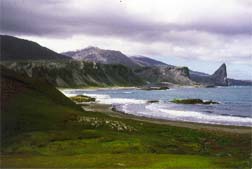
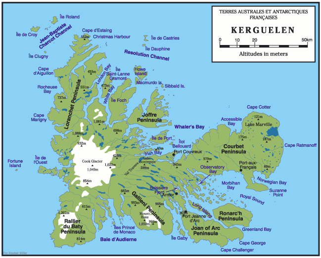
Bay Larose shoreline & cliffs on Kerguelen (Photographer: Dominique Weis / FNRS) The region is part of the French Southern and Antarctic Territories – Terres Australes et Antarctiques Françaises (TAAF), which also includes Terre Adélie (Antarctica), the Crozet Archipelago, the tiny islands of Amsterdam / Saint-Paul, and – since January 2005 – the Scattered Islands (fr. Îles Éparses) surrounding Madagascar. Topographic FeaturesThe main island, Grande Terre, is of volcanic origin. About 150 km (93 mi.) long east-to-west and 120 km (75 mi.) north-to-south, it is the third largest island belonging to France (after Grande Terre in New Caledonia, and Corsica). Covering an area of 6,675 km² (2,577 mi²), it has a highly irregular coastline with a number of large peninsulas linked to the island by low, narrow isthmuses. These large features are further sub-divided by fjords into smaller peninsulas. Remarkably, despite its total area, no point on the main island is more than 20 km (12 mi.) from the sea. Inland, the main features are the numerous valleys and ridges with the highest point, the glaciated Mount Ross, reaching a height of 1,850 m (6,068 ft.). Mount Ross is the youngest volcanic edifice recognized in the Kerguelen Archipelago. The Kerguelen Islands lie in the Northern part of the Kerguelen-Gaussberg ridge, having been built up by a series of thick lava flows over millions of years. Cook Glacier covers nearly one third of the island, and the abundant rainfall combined with glacial meltwater keeps numerous streams and lakes full of water. Peat marshes, lignite, and guano deposits are found on the island. Satellite IslandsThe following is a list of the most important adjacent islands:
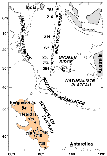
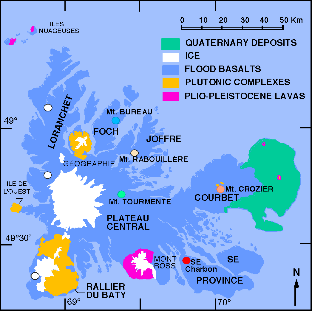
Origins of the Kerguelen PlateauA 2,300-km (1,429-mi.) -long geologic formation known as the Kerguelen Plateau stretches across the southern Indian Ocean near Antarctica (see map). This structure, the world's largest submerged plateau, was once thought to be a fragment of Antarctica that splintered off when the Indian Ocean began to form. However, an Ocean Drilling Program which bored into the basement rock of the submerged plateau found it to be composed of basalt, the typical oceanic crust formed from molten mantle rock that rises to the surface. In chemical composition, the Kerguelen Plateau basalts are a rare intermediate between two different types: those that flow out of mid-ocean ridges and those that erupt out of hotspot locations such as Hawaii. It remains unclear what kind of volcanic activity formed the plateau. (Refer to the Kerguelen Geologic Map to see relative composition of the island.) While more than a kilometer's depth of water now covers the plateau in all but three locations, researchers believe that these basement basalts erupted when the area was either above water or very close to the surface about 97 million years ago. Soil and vegetation probably covered parts of the plateau, because there are claystones, siltstones and small pieces of wood in the sediments blanketing the basalts. The plateau then apparently began sinking slowly into the ocean. Limestones containing fossils of urchin-like creatures and other animals testify that the plateau was once at a shallow depth. Over the last 60-70 million years, however, this area has subsided more rapidly. At some time, the ocean over the plateau began to cool as a continent-circling ocean current started to seal off the Antarctic climate, sending it into its current deep-freeze state. It appears that icebergs from a glacial cap on Antarctica first reached the Kerguelen plateau during the early Oligocene period, which began 37 million years ago. ClimateKerguelen's weather is harsh, with rain, sleet or snow falling more than 300 days a year; it is not unusual to get snow at sea level in the middle of the summer. Winds blow continuously from the west, as the islands lie in the path of the "Furious Fifties". Averaging 110 km/hr (68 mph) year-round, sustained winds of 150 km/hr (93 mph) are commonplace, and gusts of up to 200 km/hr (124 mph) have been recorded. Appropriately enough, the lone chapel on the island is called Notre Dame du Vent (Our Lady of the Wind). As Kerguelen lies on the Antarctic Convergence where upwelling cold water from the Antarctic mixes with the warmer waters of the Indian Ocean, birdlife and marine mammals are abundant. The state of the sea reflects the high wind speeds, with wave heights of 12-15 m (40-50 ft.) being common. The sea around Kerguelen, however, remains ice-free year-round. While rare, icebergs which have traveled from Antarctica are occasionally spotted off the coast.
Visit Infoclimat Europe for today's hour-by-hour report of temperature, wind-chill factor, rainfall, relative humidity, dew point, average wind speed, barometric pressure, and visibility at Port-aux-Français. Archives of past weather statistics are also available, searchable by date. Flora & FaunaAlthough the windswept, treeless countenance of these islands may present a bleak and barren face to humans, the redeeming quality of this hostile environment may very well be its teeming and colorful population of wildlife. Birds, in particular, find a welcome refuge in this land so devoid of human dominance. Thirty species of birds nest on the island – including Rockhopper, Macaroni, Gentoo and King Penguins; albatross, Giant Petrels, skuas, sheathbills and the Kerguelen Tern. In addition, the southern elephant seals and Kerguelen fur seals have re-established a secure haven here, following near-extinction in the 19th century. 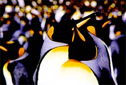
King penguins gather on Kerguelen (Photographer: Dominique Weis / FNRS) Kerguelen Terns, like their cousins the Arctic and Antarctic Terns, are slender, long-winged grey and white birds. They have bright red bills, orangish-red legs and feet. Their heads are donned with conspicuous black caps which may be streaked with white during the summer months. Quite gregarious in nature, fishing in flocks of up to several hundred, terns are also accomplished flyers and long-distance travelers, enjoying a life-span of 20 years. Albatrosses are considered by many to be the most majestic of all Antarctic birds, with a life-span which can exceed 50 years. Strikingly graceful, with modified wings to maximize the updrafts and thermals over the open ocean, albatrosses are supreme gliders. Adults have been recorded flying up to 550 miles per day, at a speed of 80 km/hr (50 mph). The black-browed albatross, gray-headed albatross, and light-mantled sooty albatross all call Kerguelen home. Macaroni penguins are the most abundant of sub-Antarctic/ Antarctic penguins, with an estimated breeding population of 11.8 million pairs. Orange tassels that meet between the eyes distinguish the macaroni penguin. (The name 'macaroni' derives from the 18th century dandies who made the grand tour to Italy and affected continental tastes and fashions, dying their hair in streaks.) The penguins lay two eggs; the first is kicked out of the nest after the second is laid and only one egg ever hatches. They can dive to 260' but prefer shallower dives for hunting. 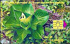
Télécarte (pre-paid phone card) depicting Kerguelen cabbage In late 1998, the environmental organization Greenpeace embarked on an expedition to expose pirate fishing in the Southern Ocean. During that expedition the crew of the M/V Arctic Sunrise discovered the notorious pirate fishing vessel, Salvora, fishing illegally for Patagonian Toothfish just off the Kerguelen coast. The vessel immediately fled, and a 16-day and 2700 nautical mile chase to the Indian Ocean island of Mauritius ensued. (Follow a chronological account of that expedition.) Though the varieties of plant life on Kerguelen can be described as limited, to say the least, that which exists consists mainly of tussock grass (Poa cookii), mosses (Azorella selago and Acaena adscendens), and the famous Kerguelen cabbage (Pringlea antiscorbutica). This latter species, belonging to the same family as common cabbage (Brassicaceae), has evolved a unique method of cross-pollination which relies on Kerguelen's winds – since there are no flying insects on the island. The leaves of the cabbage contain a pale-yellow, highly pungent essential oil which is rich in ascorbic acid (vitamin C); this made it a useful dietary supplement against scurvy for early sailors. Discovery & ExplorationIn the belief that a massive southern continent must exist to "balance" those of the northern hemisphere, King Louis XV of France commissioned the French navigator, Chevalier Yves-Joseph de Kerguelen-Trémarec, to discover such a continent for France. Commanding two vessels of the Royal French Fleet, the Fortune and the Gros-Ventre, Kerguelen left Mauritius on January 16th, sailing through mist, fog and storms to discover the islands on February 12th, 1772. 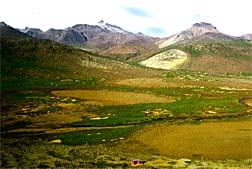
Inland view of Kerguelen (Photographer: Dominique Weis / FNRS) Unable to anchor and having lost contact with the Gros-Ventre, he returned to Mauritius in the Fortune to make repairs to his damaged ship. Meanwhile, the captain of the Gros-Ventre – Charles Marc du Boisguehenneuc – landed at a point now known as Gros-Ventre Cove, and annexed the island in the name of King Louis. Although he had never set foot on the islands, Kerguelen returned to France claiming they were inhabited, with forests, fruit, pastures and untold riches. In his much-exaggerated account, Kerguelen called them La France Australe, while the British explorer Captain Cook, who was to arrive here later, rather more candidly described the area as Desolation Islands. Nevertheless, Kerguelen's deceit won him the royal approval for another expedition. On his second foray, this time with a flotilla of three ships, Le Roland, l'Oiseau and La Dauphine, the islands were spotted on December 14, 1772. Kerguelen (aboard Le Roland) once again failed to land. However, the officer Henri Pascal de Rochegude (aboard l'Oiseau) managed to get ashore on January 6, 1773, again claiming the islands for France. Two days later, a disillusioned Kerguelen put about and returned to France, his crews ravaged by scurvy. King Louis was apparently not amused by these flights of fancy, and imprisoned Kerguelen in a château near Saumur. During the political upheaval of the French Revolution, Kerguelen was perceived to be a "victim of the monarchy", and was released. Appointed as manager of the port at Brest, he died in 1797. Hope Cottage, Pointe Charlotte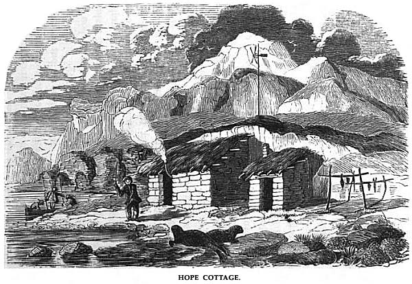
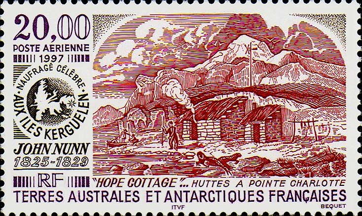
Engraving of Hope Cottage, built on Courbet Peninsula by the shipwrecked John Nunn and his crew in 1825. (click on image to enlarge) Coordinates: -49.299953, 70.532227 or 49°17'59"S, 70°31'56"E. While waiting two years and three months to be rescued when their sloop Favorite was shipwrecked at Kerguelen in 1825, the British sealer and cartographer John Nunn and his crew spent some miserable months trying to survive on Saddle Island (now called Île de l'Ouest), buffeted by the merciless westerly winds. Nunn concluded that there was a better chance of being discovered on the southeastern part of Grande Terre, the main island, so his group gradually skirted the southern coast in search of a place to settle in. After passing Shoal-water Bay (now called Baie Norvégienne), they were eventually able to find an area suitable for monitoring passing ships at Long Point (now called Pointe Charlotte) on the east coast of Courbet Peninsula, where they built two comfortable cabins which they baptized Hope Cottage. (see satellite view) The group was finally spotted in 1827 by Captain Alexander Distant on the schooner Sprightly, belonging to the celebrated shipowner Enderby of London. Nunn and his crewmates joined the Sprightly in hunting whales and elephant seals until 25 March 1829, at which point they were finally returned to Harwich, England – four years after the shipwreck. In 1997, the French post office issued a 20-franc air-mail stamp to commemorate the shipwrecks and the construction of Hope Cottage. See: "Narrative of the Wreck of the Favorite on the Island of Desolation: Detailing the Adventures, Sufferings and Privations of John Nunn; an Historical Account of the Island, and Its Whale and Seal Fisheries: With a Chart and Numerous Wood Engravings." – John Nunn, W. B. Clarke (editor). The Arch of KerguelenCoordinates: 48°41'25.97"S, 69°04'17.84"E or decimal: -48.690547, 69.071622. Geological arches caused by erosion can be found around the globe. In fact, human observation of these natural wonders may have contributed to the architectural forms known as the post and lintel used from Neolithic times, or the vaulted arch which came later. 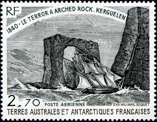
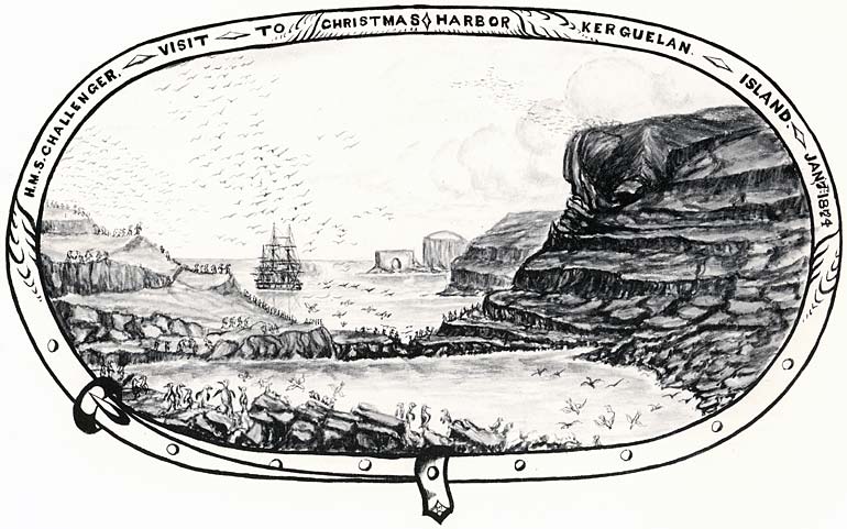
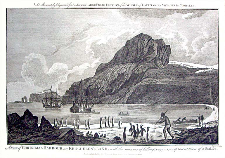
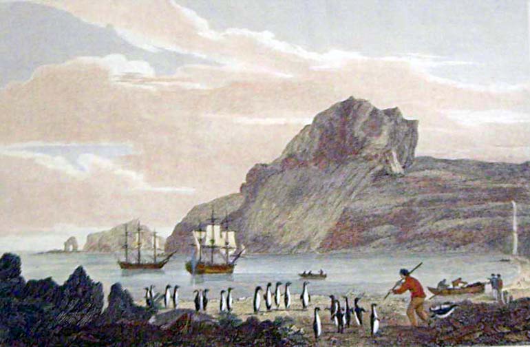
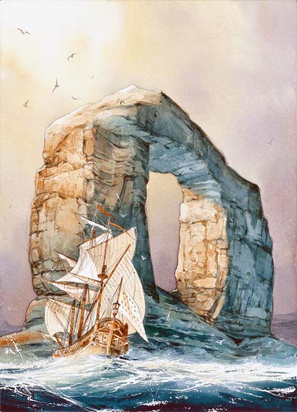
French postage stamp depicts the HMS Terror ship sailing past the Arch of Kerguelen in 1840 (click on image to enlarge) One such natural phenomenon is a unique basalt formation situated on a tiny peninsula near the northern extremity of Loranchet Peninsula on Grande Terre (see map). It was first discovered in January 1774 by the navigator Chevalier Kerguelen-Trémarec on board Le Roland, during his second expedition to the region. On his charts, Kerguelen named the structure "Le Portail" (en. portal or gate). On 25 December 1776, Captain James Cook – during his third and last expedition on the HMS Resolution – anchored in a bay at the northern tip of Kerguelen, which he aptly named "Christmas Harbour" (now known as Baie de l'Oiseau). There – at the southern point of the inlet's mouth – Cook had also observed the splendid arch, which towered to an estimated 130 m (427 ft.)[1]. "... to make it more remarkable its south point terminates in a high rock which is perforated quite through so as to appear like the arch of a bridge. We did not see such a nother on the whole coast." (The Journals of Captain James Cook on his Voyages of Discovery) Over the years, numerous explorers and captains of whaling ships have remarked on the monumental formation. Tales told by whalers from New England were most likely the inspiration for its mention in a novel written by Edgar Allen Poe in 1838, The Narrative of Arthur Gordon Pym[2]. During their expedition in 1840 with two ships – the HMS Terror commanded by Francis Crozier, and the HMS Erebus commanded by James Clark Ross (after whom the Ross Sea and Ross Island are named) – the latter confirmed observations of his predecessors, adding that "Inside the arch, we see fragments of silicified (i.e. petrified) wood embedded in the basalt." A four-year scientific expedition on the HMS Challenger, led by Captain George S. Nares, stopped at Christmas Harbour in January 1874. View a magnificent engraving of the ship moored in the bay, with hundreds of penguins on shore, and the Arch of Kerguelen seen in the middle background.[3] On their 1908-09 charting expedition, the Rallier du Baty brothers were among the last mariners to see the Arch of Kerguelen in its majestic splendor. Alas, the upper rim of the arch collapsed around 1910, leaving only two giant pillars and a pile of stone rubble between them. While the arch was created by erosion in the first place, the merciless elements so common to Kerguelen had sadly taken their toll on the venerable structure just 136 years after its discovery. In 1979, the TAAF issued a 2.70-franc air mail stamp (48 x 36 mm in size), engraved by Pierre Béquet, depicting the HMS Terror ship sailing past the Arch of Kerguelen in 1840.
[1] By comparison, l'Arc de Triomphe de l'Étoile in Paris — the world's largest triumphal arch — is only 49.5 m (162 ft.) in height. Next page >> 19th to 20th Century, World War II, Post-War Years, The Present-Day Base Station, Related Videos, Useful Links |
||||||||||||||||||||||||||||||||||||||||||||||||||||||||||||||||||||||||||||||||||||||||||||||||||||||||||||||||||||||||||||||||||||||||||||||
|
||||||||||


