| home | • | bookstore | • | boutique | • | contact us | • | news headlines | • | help! | • | share | • | site map | • | travel center |
 |
 |
 |
| |||||||||||||||||||
| |||||||||||||||||||

|
|
|||
|
La Désirade • Isles des Saintes • Marie-Galante Saint-Martin • St-Barthélemy • Bibliography • Links
MARIE-GALANTENamed after Columbus' flagship, the Maria Galanda, this is the largest island dependent on Guadeloupe, and is accessible by ferryboat from Saint-François or Pointe-à-Pitre — or by airplane (see map). Although the climate is rather dry, the luxuriant vegetation has made her the home of sugar cane and subsequently of rum distilling. Visitors who wish to sample some of the best rums should beware of their livers: these native concoctions may be up to 59° proof! SAINT-MARTINSaint-Martin, one of the Leeward Islands in the Caribbean Sea (see map), lies about 240 km (150 mi.) northeast of Guadeloupe, 250 km (155 mi.) east of Puerto Rico. The area is 86 km2 (33 mi2). The northern portion of the island (1990 pop., 28,518) is administered from Basse-Terre on Guadeloupe as a part of France's overseas territories. Its capital and principal town is Marigot. The southern section (1993 est. pop., 35,841) — called Sint Maarten — is administered as a part of the Netherlands Antilles from Philipsburg, located on the island. Tourism, salt extraction, sugarcane and cotton cultivation, rum distilling, raising livestock, and commercial fishing form the basis of the economy. Originally settled by Carib Indians, the island was discovered by Christopher Columbus in 1493 and settled by the Spanish in 1640. In 1648, French and Dutch prisoners of war supposedly partitioned the island as it is today. ST-BARTHELEMY
St-Barthélemy, a volcanic land mass of only 8 square miles (see map), was discovered by Christopher Columbus in 1493 and was named after his brother Bartolomeo. The native Carib Indians ferociously resisted all attempts by the Europeans to settle on the island. In 1648, a failed colonization attempt was made by French settlers from St. Kitts. A few determined peasants from Brittany and Normandy survived the resistance and in 1660 a second attempt at settlement was successful. In 1673 the island became a part of France and a part of the government of Guadeloupe. By 1687, St. Barth had a population of 500. In 1784 Sweden's King Gustav III was given the island by Louis XVI of France in exchange for a warehouse in Göteberg Harbor and in 1785 Gustav declared the island a free port. Swedish settlers arrived and the island prospered as commercial traffic transited through the newly named harbor of Gustavia. The 19th century was not kind to St. Barth — or St. Barts, as it is also called. Numerous misfortunes including hurricanes, droughts, yellow fever epidemics, and a disastrous fire descended upon the island. As steam power replaced wind, ships were able to take more direct routes to and from American ports, bypassing St. Barth. Ridding itself of an increasingly heavy economic burden, Sweden sold the island back to France in 1878 for 320,000 francs. Provisions of this agreement required the island remain duty free and that the population never pay taxes! Many of the local inhabitants are descendants of the early settlers from Brittany and Normandy and their language still reflects traces of the Norman French. The Swedish influence remains to this day as does the distinction of being a duty free port. With the landing of the first plane, a two-seater flown by Rémy de Haenan, tourism was able to develop. However, the airstrip, even today, is not large enough to handle jetliners bringing an onslaught of visitors.
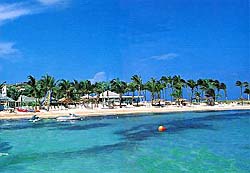
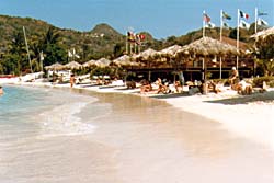
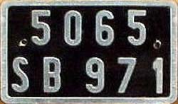
Sources: 2001 Grolier Multimedia Encyclopedia, ©2000 Grolier Interactive Inc. ; The Encyclopedia Americana, a division of Grolier Online ; French Caribbean International (history of Îsles des Saintes) ; Antilles Info Tourisme (descriptions of La Désirade and Marie-Galante) ; and www.StBarth.com web site (history of St-Barthélemy). — All Rights Reserved. Images: Unofficial flag of Guadeloupe from Flags of the World web site. Maps of Guadeloupe and Saint-Martin © Lonely Planet. Maps of La Désirade, Îsles-des-Saintes, and Marie-Galante © 1993 Hachette Livre. Map of St-Barthélemy © 1996 Magellan Geographix. François Joseph Paul de Grasse, from the Embassy of France in the U.S. Beach and azure waters on St. Barts, from islandinns.com © 2001 Island Inns LLC. Radio St. Barth FM, from www.RadioStBarth.com and StBarth.fr, le site portail de St Barth! web sites. Beach at Baie de St. Jean on St. Barts © 1983-2002 Ian C. Mills, webmaster for DiscoverFrance.net. St. Barts license plate, from Immatriculation des véhicules des DOM-TOM web site. St. Barth Airport (and descending airplane), from Travel Grotto - St. Barthélemy and www.StBarth.com web sites. Copyrights are attributed to each source — All Rights Reserved. La Désirade • Isles des Saintes • Marie-Galante Saint-Martin • St-Barthélemy • Bibliography • Links
|
||||||||||||||||||||||||||||||||||||||||||||||||||||||||||||

|
||||||||||