| home | • | bookstore | • | boutique | • | contact us | • | news headlines | • | help! | • | share | • | site map | • | travel center |
 |
 |
 |
| |||||||||||||||||||
| |||||||||||||||||||
|
|
|||
|
Dordogne River • Eure, Loir, & Cher Rivers • Garonne River • Isère River Loire River • Marne River • Marne-Rhin Canal • Meuse River • Moselle River Oise River • Rhine Canals • Rhine River • Rhône River • Saône River • Seine River Somme River • Vienne River • Yser River • Other Rivers 
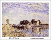
The Seine, the best-known river in France, passes through Paris and drains the Paris Basin. It is 482 mi. (776 km) long. The major tributaries are the Marne, Oise, and Yonne rivers. The Loire, with a length slightly more than 620 mi. (1,000 km), is France's largest river. Its major tributaries are the Sarthe, Loir, Vienne, Cher, and Allier. The Rhône — the deepest river, with the largest volume of flow — has a length of only 325 mi. (523 km) in France (the upper reaches are in Switzerland) and receives, among its major tributaries, the Saône and Isère rivers. The Garonne and Dordogne rivers, also important, join below Bordeaux to form the Gironde. The Burgundy CanalProviding a passage through Tonnerre (Département de l'Yonne) to the north and Dijon (Département de la Côte-d'Or) to the south, the Burgundy Canal (with its 189 locks) connects the valley of the Yonne River to the plains of the Saône, cutting a 150 mi. (242 km) path through the meadows and hills of Tonnerrois, Auxois and the lush valley of Ouche. Noteworthy historic locations abound along this meandering route, promising a memorable and pleasant cruise. A handful of barge operators offer their intimate cruise boats (known as pénichettes) for rental along the stretch between Dijon and Laroche Migennes.
Source: Guide Interactif du Tourisme Fluvial.
The Canal du CentreThe Canal du Centre is the name of two separate canals in Europe, one in France, the other in Belgium. The French canal covers a distance of 73 mi. (118 km) in Burgundy between the Saône River at Chalon-sur-Saône and the Loire at Digoin. Designed by the French engineer Emiland Marie Gauthey (1732-1806), it was built between 1783 and 1802 and constituted the final link in the first inland-waterway route between the English Channel and the Mediterranean Sea. The Canal du MidiThe Canal du Midi, also called the Canal du Languedoc, is a system of navigable waterways in southern France that links the Mediterranean Sea with the Atlantic Ocean. Measuring some 204 mi. (360 km) in all, it includes 328 structures such as locks, tunnels, bridges, and aqueducts. Built from 1667 to 1694 and designed by engineer Pierre Paul Riquet (1604-80), this project is believed to be the first in which explosives were used for blasting rock. The Canal du Midi is an impressive achievement in the history of civil engineering, harmonizing with the landscape while mixing utilitarian function with aesthetic appeal. A UNESCO World Heritage Site, the canal is still in operation, today mainly carrying barge traffic. In addition to its commercial use, the Canal is extremely popular for its tourist cruises on specially converted barges.
Source: Grolier Multimedia Encyclopedia v14.0.0, Grolier Interactive Inc., Danbury, CT. The Doubs RiverThe Doubs River is approximately 270 mi. (435 km) long, rising in the Jura Mountains of eastern France, and flowing northeast, forming part of the French-Swiss border, then looping into western Switzerland before turning back into France where it meanders southwest to empty into the Saône River. Lake of Brenets, a natural widening in the river, is a tourist center; at the northern end of the lake the river drops 88 ft. (27 m). The Doubs is heavily canalized and passes through several industrial cities including Montbéliard and Besançon.
Source: Columbia Encyclopedia, Paul Lagasse, Lora Goldman, Archie Hobson (Editors). The Dordogne River"France may one day exist no more, but the Dordogne will live on just as dreams live on and nourish the souls of men." The Dordogne River derives its source from the puys — the highest points at the heart of the Massif Central, a formation consisting of granite and crystalline rocks produced by volcanoes. As it winds its way through the department of Dordogne, the river's waters feed some of France's richest agricultural lands around Périgord to its north. On its southern side, the limestone causse is not so lush but there are treasures of a different kind: underground chasms and grottoes, and some of the finest medieval religious architecture in France. The many castles and bastides (fortified towns) are relics of the bitter fighting throughout the Middle Ages.
Source: The National Geographic Traveler - France, Rosemary Bailey (Editor).
The Eure, Loir and Cher RiversIt is the Eure and Loir Rivers which lend their names to the department of Eure-et-Loir (28) on the Beauce plateau of the Centre region. The Eure flows northward through Eure-et-Loir's capital, Chartres — reknowned for its High Gothic cathedral. Although Louis XIV requested that Vauban and La Hire build an aqueduct to transport water from the Eure River to the fountains of Versailles, it was never completed; the remains of a 3-story aqueduct may be seen straddling the grounds of the Château de Maintenon. The Loir (lwär) is approximately 193 mi. (310 km) long, flowing southward through Châteaudun in Eure-et-Loir, then through the towns of Vendôme and Montoire-sur-le-Loir in the northwestern portion of the department of Loir-et-Cher (41), and generally SW through a fertile agricultural region to join the Sarthe River north of Angers in the department of Maine-et-Loire (49) in the Pays de la Loire region. Loir-et-Cher is so named because it is also home to the river Cher, which is navigable and flows through Mennetou-sur-Cher and Montrichard in the south. Approximately 200 mi. (320 km) long, and flowing generally NW across central France, the Cher joins the Loire below Tours in Indre-et-Loire (37). The Berry Canal parallels part of the river.
Sources: French-at-a-Touch.com, ParisGolfTours.com, and the Columbia Encyclopedia, Paul Lagasse, Lora Goldman, Archie Hobson (Editors). Next page >> Garonne, Isère, Loire, Marne & Meuse Rivers, and the Marne-Rhin Canal
Dordogne River • Eure, Loir, & Cher Rivers • Garonne River • Isère River Loire River • Marne River • Marne-Rhin Canal • Meuse River • Moselle River Oise River • Rhine Canals • Rhine River • Rhône River • Saône River • Seine River Somme River • Vienne River • Yser River • Other Rivers |
||||||||||||||||||||||||||||||

|
||||||||||