| home | • | bookstore | • | boutique | • | contact us | • | news headlines | • | help! | • | share | • | site map | • | travel center |
 |
 |
 |
| |||||||||||||||||||
| |||||||||||||||||||

|
|
|||
|
If you are lucky enough to have lived in Paris as a young
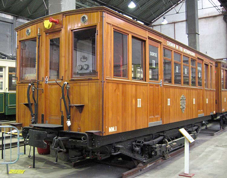
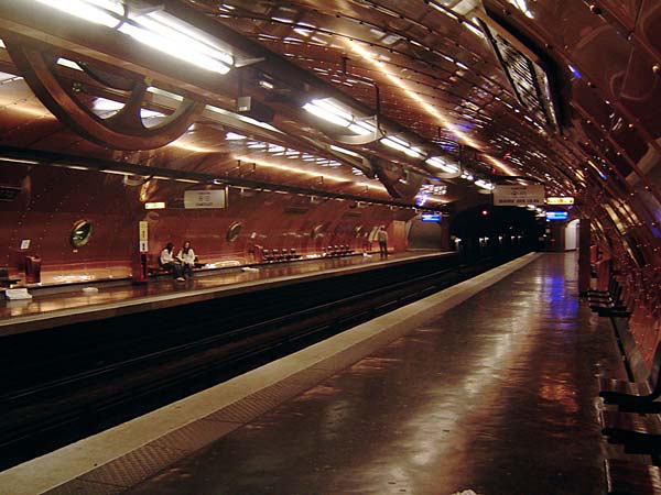
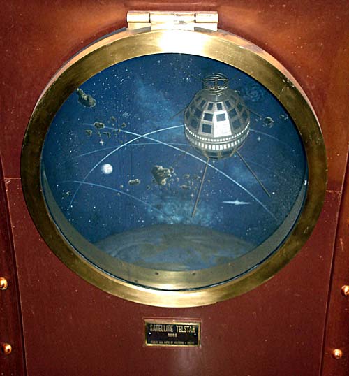
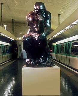
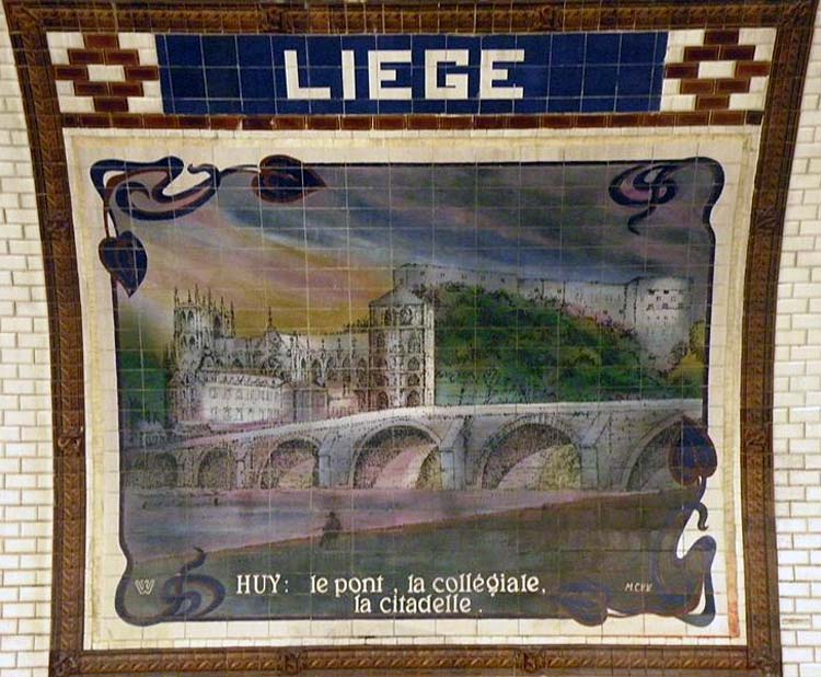
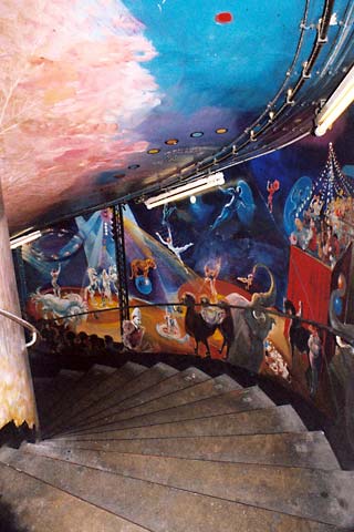
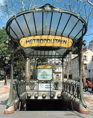
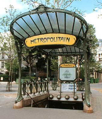
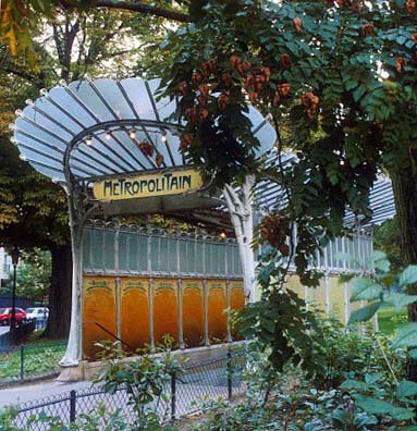
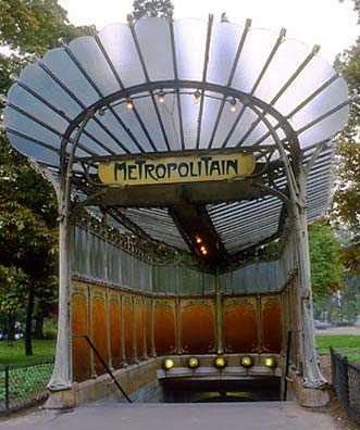
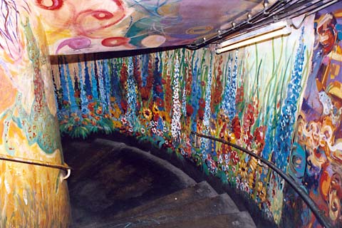
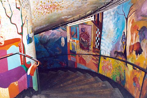
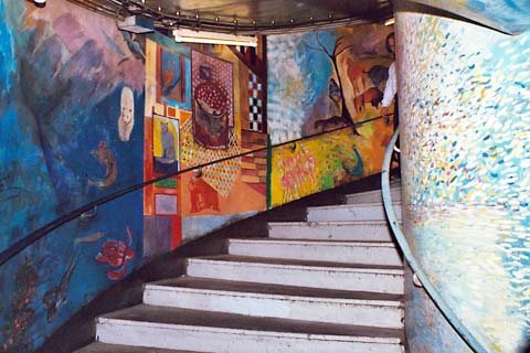
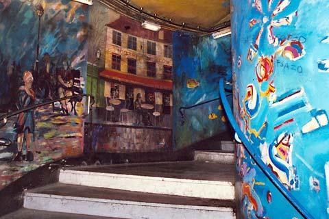
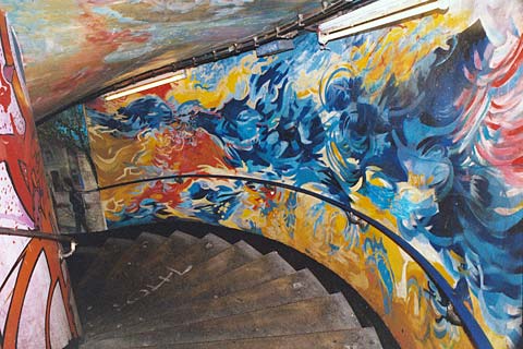
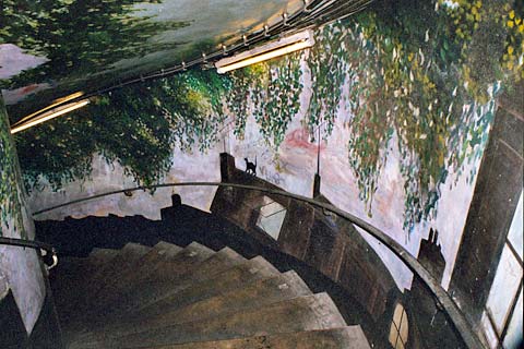
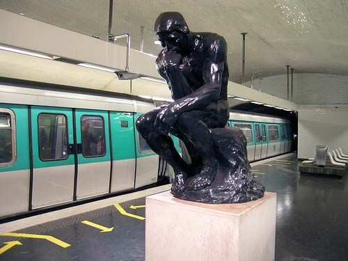
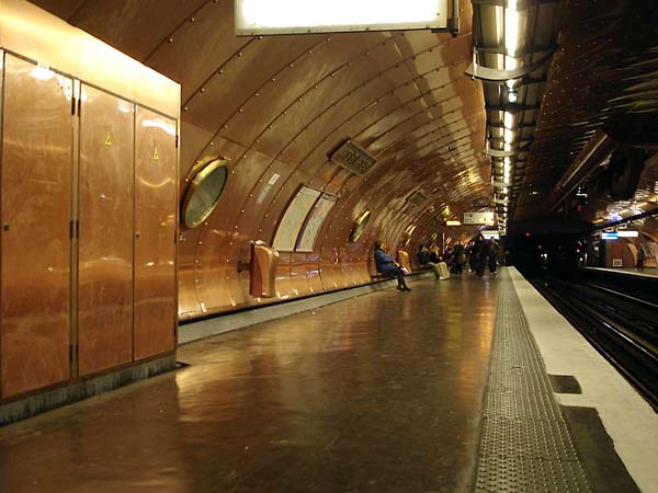
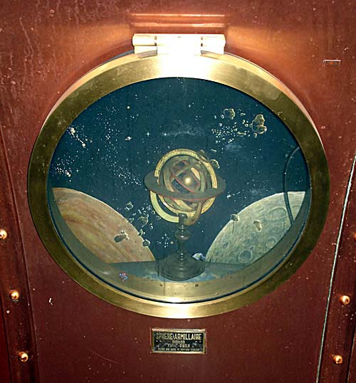
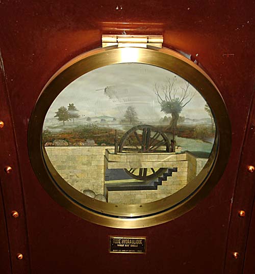
Since Paris is such a compact city (roughly 6 miles across), much of it can be covered on foot – especially the primary sightseeing spots in the city's center. There will be times, however, when a métro or bus ride is unavoidable – and even welcome. History of the Métro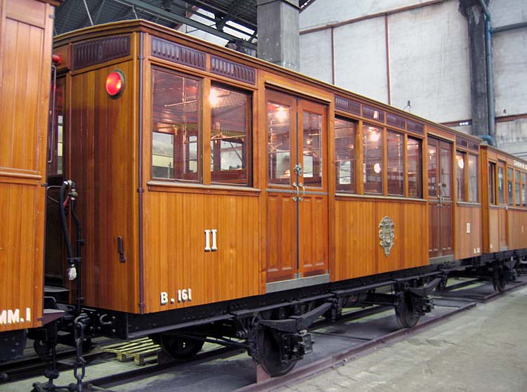 Wooden Métro cars placed in service July, 1900 © Guillaume Potier from Le Métro Parisien (click to view gallery) Evidence of plans to build the métropolitain (or the Nécropolitain, as it was dubbed by one wit) existed as early as 1845, though the first line was not completed until July 19, 1900. (Line 1, as it is still called, ran from Porte de Vincennes to Porte Maillot; it has since been extended – from Château de Vincennes to La Défense.) Following the construction of the Eiffel Tower by eleven years, this elegant transportation system stole the show, and remains to this day a model of efficient public transportation. While the engineer Fulgence Bienvenüe was in charge of construction, architect Hector Guimard is credited for the charming and elaborately sculpted Art Nouveau entrances. The system boasts 213 km (132 miles) of track and 16 lines (including two auxiliary lines), shuttling 3553 cars on a precise schedule between 303* stations (not including RER stations), 87 of these offering connections between lines. It is said that every building in Paris is within 500 meters (3/10 mile) of a métro station. Roughly 6 million people per day patronize the métro, which employed 10,141 (not including RER) in 2010. The transit authority which operates and maintains the city's métro system, lines A & B of the RER (express trains), an extensive bus network, and four tram lines is called Régie Autonome des Transports Parisiens. The RATP was created on March 21, 1948, by combining the assets of the Compagnie du Chemin de Fer Métropolitain de Paris (CMP) and the Société des Transports en Commun de la Région Parisienne (STCRP). RATP reported a total of 3.1 billion passenger journeys in 2011 (all forms of transport) and gross revenues of €2.35 billion (from bus, métro, RER fares) in 2012. * Newest stations, lines, and opening dates: "Mairie de Montrouge" (line 4 terminus; 23 March 2013); "Front Populaire" (line 12; 18 December 2012); "Pointe du Lac" (line 8 terminus; 8 October 2011). Station Design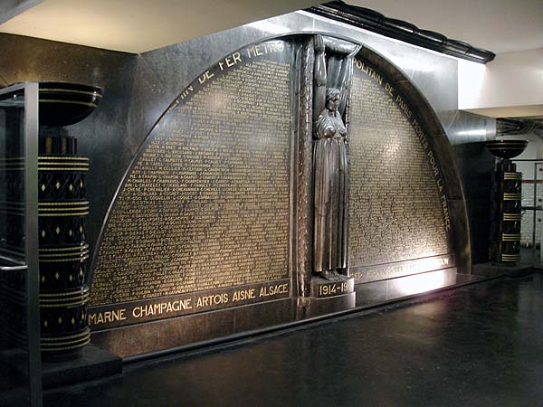 Monument aux morts, Richelieu-Drouot métro station platform (line 8) (click to enlarge) Some of the métro stations are worth a visit in their own right. For example, the stop for the Louvre (line 1) gives one the impression that the train has pulled into the Museum itself: the immaculate marble walls are lined with exhibits and replicas of art works, with glass cases containing various sculptures. On a platform of the Richelieu-Drouot station (line 8) is a war memorial, carved in black marble by sculptor Carlo Sarrabezolles in 1931. It is dedicated to the agents of the metropolitan railway who died in service for France during World War I. The Arts et Metiers (line 11) station's platforms were redesigned in 1994 by Belgian comic book artist François Schuiten. The ceiling and walls are clad with riveted copper, punctuated with faux portholes – reminiscent of a Jules Verne science fiction novel. On line 13, Varenne offers exhibits from the nearby Rodin Museum (including a replica of The Thinker), while Liège is paneled with beautiful ceramic tiles donated by the Belgian government. Abbesses (line 12) features elaborate murals in its 7-story spiral staircase descending beneath one of the more elaborate of Art Nouveau entrances. Abesses Porte Dauphine 1 Porte Dauphine 2 mural 2 mural 3 mural 4 mural 5 mural 6 mural 7 The Thinker Arts et Métiers porthole 2 porthole 3
Station Names
Travel Tips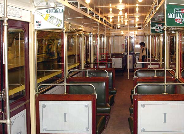
Interior of a Sprague-Thomson first-class car, seen during a special outing on 24 March 2007 (line 12) – note the leather seats Though this author had to play the "dumb tourist" to avoid being severely fined by a contrôleur for riding in a first class car with a second-class ticket many years ago, the métro system – in a rare display of egalitarianism – did away with first class cars in August 1991. A word of caution: though a single-fare ticket is valid for an entire continuous trip – including connections (up to 90 minutes) – be sure to keep your ticket until you leave the system at your destination; being caught without it means an instant fine of €40, payable in cash on the spot (unless you wish to acquaint yourself intimately with the French judicial system). While Paris has a lower incidence of violent crime than most major cities, it is wise to keep your wits about you (particularly in the crowded venue of a métro station) and guard against pick-pockets, whose scams can be particularly creative at times. Perhaps as a testament to the Artful Dodger and Fagan's pick-pocketing ragamuffins in Oliver, the operatives ply their scam in pairs – frequently on the escalators on the way up to street level: One will stop suddenly at the top exit, as though he's dropped something; while you try to avoid running over him, you're jostled from the rear by the second one, who lifts your wallet. It's recommended that gentlemen carry their wallets in their jacket's inner pocket, rather than in a rear pants pocket. Likewise, ladies should hold their purses in hand, instead of slung by their strap from the shoulders. Thieves commonly cut the strap of a dangling purse with a utility knife. (Refer to our page "Feeling Safe in Paris" for more tips.) Should you happen to see everyone leaving a packed métro station following an announcement in French on the public address system, chances are you are witnessing one of their periodic strikes (or grèves). These manifestations occur from time to time when the unions are displeased with government, or during elections. Look at it this way: you'll get a chance to explore sections of Paris you might otherwise have only passed underground! Maps & Directions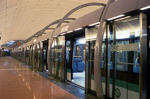
Météor automatic subway line 14 at Gare de Lyon. © F. de La Mure / M.A.E. Signage in Paris métro stations is abundant and easily followed: every station offers a big plan of the network outside the entrance and several inside. Lines are color-coded and numbered, and are also named according to the city gate (fr. porte) or suburban town at the end of the line. For example, Line 4 running to the north will be indicated as going in the direction of Porte de Clignancourt, whereas its southern terminus (formerly Porte d'Orléans) was recently extended to Mairie de Montrouge. Some lines may end a few stops beyond the Periphérique (beltway surrounding Paris), into neighboring suburbs. Numerous interchanges (correspondances) make it possible to travel throughout the city in a more or less straight line. Châtelet has the longest interconnecting passageway between lines, with a 600-foot long moving sidewalk. Free maps are also available at most stations, which provide the basics for navigation. If you want detailed breakdowns, we recommend the following, which are available at most newsstands and bookshops:
For the latest in subway technology, try the express stations' computerized route-finders: at the touch of a button, you'll be shown four alternative routes to your selected destination, on foot or by public transport. Online Route FinderThe RATP web site offers a helpful tool (in English or French) to assist in planning your route(s) throughout Paris and its suburbs. Using their advanced search form, enter your starting and destination points (either by street address, subway stop, or even by monument – such as Tour Eiffel), travel date & French time (based on a 24-hour clock), type of transport desired (bus, rail, tram), and personal preferences (such as quickest route, least amount of walking, etc.). The system will then produce a map suitable for printing, containing detailed text instructions (lines, stops, and transfers where applicable) and estimated travel times. To plan your return trip, simply perform a new search in reverse. Do not be surprised to find French text sprinkled liberally throughout so-called "English-version" pages. The RATP spends a lot of time rearranging its content (often for inexplicable reasons), and its English versions have suffered as a result. 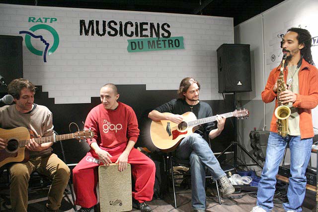
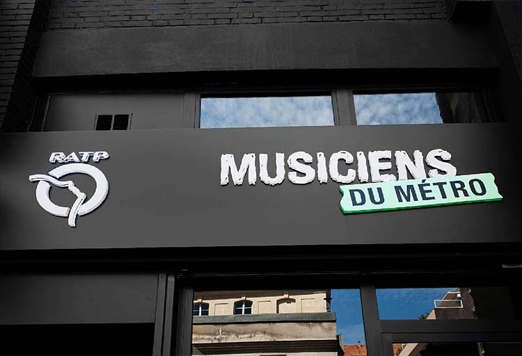
Licensed musicians playing in a Paris métro station (click to view gallery) Musicians in the Métro – A Thriving Alternative SceneAnyone who has traveled by Paris métro in the last couple of decades and walked through some of the larger stations is likely to have witnessed the presence of buskers on the platforms and in the corridors, playing a wide range of music for the public's enjoyment. The talent varies from solo folk guitarists or accordionists to small reggae groups and even the occasional classical orchestra – some replete with as many as two dozen accomplished musicians. The first-ever cultural event to be staged in the Paris métro, 1977's Métro Molto Allegro, was the musical affair that may have sparked a movement. In 1989, in collaboration with an association of street and métro musicians, the RATP gave its permission to around one hundred artists to perform in the métro stations. By 1997, so many musicians had shown an interest in performing that the RATP decided to create a more substantial body to handle their applications, the Espace Métro Accords (EMA). To this day, the EMA continues to audition and select musicians – mostly semi-professional, some professional – who are looking for a place to showcase their talents and fine-tune their repertoires. With the Rock en Seine (Saint-Cloud) and Solidays (Longchamp) festivals, tributes to Jacques Brel and Serge Gainsbourg, the hugely popular concerts at Auber, the Paroles'n'Rock campaign and – of course – the métro's licensed musicians, the RATP's commitment to supporting music is evident for all to see. Music without boundaries...
Métro music videos: (replay) |
Flashmob |
Train duet |
Buswel |
EMA
Since its creation, the EMA has received more than 10,000 applications, held over 4,000 auditions and authorized more than 3,000 artists to perform in the métro. Musicians who perform in the station corridors are as diverse as the métro passengers: all styles, ages, rhythms and nations are represented. Twice a year, in spring and autumn, the EMA auditions hundreds of candidates seeking accreditation to perform in Paris' métro stations. Successful applicants (around 350 new musicians are accredited each year) agree to play only in authorized locations and to follow certain rules. These auditions allow young artists to find an audience and hone their musical skills. Musical partnerships developed by the RATP also offer the most talented performers a chance to showcase their abilities live on stage at major music events, such as the Solidays festival (on the "Jeunes Talents" stage) or the Art Rock festival in Saint-Brieuc. For some of them, it could be their first step toward a brilliant career. After all, many of the music stars of today started out in the métro, including Alain Souchon, Manu Dibango, Jacques Higelin, Touré Kunda, Dany Brillant, Ben Harper, and – more recently – Laâm, Anis and William Baldé. In late 2008, Keziah Jones even returned to his former stomping ground for several special surprise concerts. Espace Métro Accords – 102 ter, rue de Charonne, 75011 Paris | tel. 01.58.77.40.74 | e-mail: <musiciensdumetro@ratp.fr>. Clandestine performances on the trains...On any given day, passengers are also likely to witness untold numbers of clandestine, unauthorized performers throughout the métro network, whose talents may be somewhat less refined – perhaps they never sought an audition, or they might have been rejected by the EMA. These 'rogue' musicians – usually traveling singly or in pairs – often hop on and off the trains, performing short concerts in between métro stops. While most of them are benign, some have been known to more aggressively seek donations from a captive audience of passengers. Our best advice, if this should happen to you, is to avert eye contact – unless of course you've become happily engaged in their craft! Guided Tours of RATP FacilitiesSince 2011, the RATP has proposed a series of guided tours of its facilities for the general public, in partnership with the Seine-Saint-Denis departmental tourism committee. This year-round program offers everyone a chance to get a look at RATP from behind the scenes. Did you know that, each day, 10 million trips are made on RATP networks? Or that 234 different professions contribute to the system's smooth functioning? As a local cultural activity that is both easily accessible and enriching, these guided tours also provide passengers the opportunity to meet and talk with RATP staff, and to share in the passion they have for their work. A diversified selection of toursTour programs focus on RATP activities in several areas. The following are examples of tours which were conducted in March and April of 2013:
The tour price is €5 per person, per visit; minimum age is 16. For more details and to register, see the Seine-Saint-Denis tourism committee (content in French only). Participation is limited, so reservations should be made well in advance. You can also register your e-mail address to be put on a waiting list. Wi-Fi Connections – Free & Fee-basedIn addition to the many hundreds of wi-fi hotspots offered in parks, municipal buildings, cafés and restaurants across the city, Paris is also gaining some momentum with connectivity in its transportation hubs. In June 2012, the provider GOWEX announced coverage across parts of Paris' public transport system – including railway stations, commuter lines and bus stops. Paris' Métro stations already have wi-fi coverage courtesy of the service provider, SFR. However, SFR charges a premium for this service while GOWEX's offering is free. As always, we advise users to exercise extreme caution when accessing the Internet via wi-fi, especially on free networks which often do not provide adequate levels of security against hackers and spoofers who can steal your banking and other passwords over the air. Be sure to install a competent personal VPN (Virtual Private Network) on your portable device or laptop computer before accessing any password-protected sites! Choose your VPN password carefully: 10 characters of mixed upper- and lower-case letters plus a string of difficult to guess numbers are best. 
RATP Apps for iOS & AndroidThe RATP has released several apps for iPhone/iPod Touch/iPad and Android mobile devices:
Next page >> Should I Buy Tickets, or a Transport Pass? |
||||

|
||||||||||


